Products
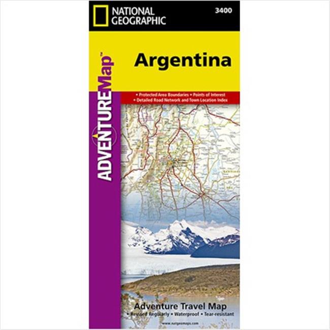
National Geographic Maps AD00003400 Argentina Map
Upgrade to unlock this product- Shipping Cost (lower 48): $10.73
- SKU: NAGGR268
- Asin: 1566955440
- Manufacturer Part #: AD00003400
- Qty Available: 25
- Shipped By: 4 days
- Stock: In Stock
Please login to view pricing details.
Product Description
Argentina Adventure Map is designed to meet the unique needs of adventure travelers detailed, durable, and accurate. Argentina includes the locations of thousands of major cities and towns with an index for easily locating them, plus a clearly marked road network complete with distances and designations for major highways, limited access highways, minor roads, and more. What sets National Geographic AdventureMaps apart from traditional road maps are the hundreds of points-of-interest that highlight the diverse, unique, and exotic destinations within Argentina including national parks and preserves, World Heritage sites, archeological sites, churches of interest, scenic viewpoints, natural points of interest, and important travel aids like airports, airstrips, rail lines, lighthouses, and harbors. The north side of the Argentina map details the most highly populated areas of the country including the provinces of Buenos Aires, Cordoba, and Santa Fe as well as the impressive landscape of the Cordillera de los Andes bordering Chile on the northwest. Vineyards in Mendoza, Argentina's world-renowned wine producing province are included, as are ski areas in this popular tourist region. An inset map shows the small province of Misiones that juts into the neighboring countries of Brazil and Paraguay. The south side of the map details Argentina's extensive coastline from Mar Del Plata to Tierra Del Fuego highlighting beaches, preserves, and areas noted for fishing and surfig. Our Argentina AdventureMap is printed in the U.S.A. The map is two-sided. Popular Places Included on the Map Patagonia, Los Glaciares National Park, Peninsula Valdes, Iguaz� Falls, Andes Mountains, Puente del Inca, Quebrada de Humahuaca and The Pampas Complete with activity symbols, ideal for exploring the country " Hundreds of points-of-interest, including the location of museums, churches, beaches, vineyards, ski areas, and scenic viewpoints " Thousands of place names " Latitude/Longitude and Magnetic Declination for use with GPS and Compass " Important travel aides including: airports/airstrips, lighthouses, harbors and rail lines. This Map is Ideal For " First time visitors and frequent recreationists " Tourists (as a guide and souvenir) " Wine enthusiasts " Ecotourism " Adventure sports activities " Historical and cultural enthusiasts About Argentina Argentina, meaning land of silver, is a rich and vast land second largest (after Brazil) in South America and eighth largest in the world. Its heartland is a broad grassy plain known as the Pampas (pronounced PAHM-pahs). At the very bottom of South America, sharing a long border with skinny Chile, this fascinating nation so steeped in European culture extends more than 3,000 miles from Brazil, Paraguay, and Bolivia in the north to the enchanted islands of Tierra del Fuego in the south.
 upgrade to unlock this product
5373261 TSA-Accepted Luggage Lock, Black - Pack of 2
upgrade to unlock this product19.0 x 13.0 x 13.0 in. Cajon Travel Storage Bag
upgrade to unlock this product13.0 x 13.0 x 20.0 in. Cajon Travel Storage Bag
upgrade to unlock this product163330 6.25 x 4.75 in. Clear Travel Pouch - Clearly
upgrade to unlock this productG3-84 Electronics Accessories Grey Stripe Travel Organizer & Gadget Bag
upgrade to unlock this product